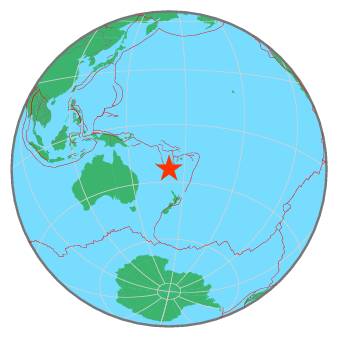
| Magnitude | 7.7 |
| Region | SOUTHEAST OF LOYALTY ISLANDS |
| Date time | 2021-02-10 13:19:59.6 UTC |
| Location | -23.250 ; 171.490 |
| Depth | 10 km |
| Distance | 528 km E of Nouméa, New Caledonia / pop: 93,000 / local time: 00:19:59.6 2021-02-11 417 km ESE of Tadine, New Caledonia / pop: 7,400 / local time: 00:19:59.6 2021-02-11 |
All data providers for this event:
Geoscience Australia, Canberra, ACT, Australia -- Canberra, Australia (AUST)Centro de Sismologia da Universidade de Sao Paulo (member of the RSBR) -- Sao Paulo, Brazil (USP)
British Geological Survey -- Edinburgh, United Kingdom (BGS)
GeoForschungsZentrum (GFZ) -- Potsdam, Germany (GFZ)
Republican Seismic Survey Center or Azerbaijan National Academy of Sciences -- Baku, Azerbaijan (RSSC)
Pacific Tsunami Warning Seismic System, Pacific Tsunami Warning Center, Ewa Beach, Hawaii -- Ewa Beach, United States (PT)
Geonet, GNS science -- Lower Hutt, New Zealand (GNS)
National Earthquake Information Center, U.S. Geological Survey -- Golden, United States (NEIC)
Pacific Tsunami Warning Center -- Honolulu, United States (PTWC)
Universidad de Panama -- Panama, Panama (IGC)
Instituto Geografico Nacional -- Madrid, Spain (IGN)
Korean Meteorological Administration -- Seoul, Korea, Republic of (SEO)
Alaska Tsunami Warning Seismic System, West Coast and Alaska Tsunami Warning Center -- Anchorage, United States (AT)
Badan Meteorologi, Klimatologi dan Geofisika -- Jakarta, Indonesia (BMKG)
Geophysical Survey of the Russian Academy of Sciences -- Obninsk, Russia (GSRAS)
Kandilli Observatory and Earthquake Research Institute -- Istanbul, Turkey (KOERI)
Further information can be found at:
National Earthquake Information Center, U.S. Geological Survey -- Golden, United States (NEIC)GeoForschungsZentrum (GFZ) -- Potsdam, Germany (GFZ)
