Seismic information
Earthquake location
Historical seismicity
Moment tensors
Regional moment tensors
Affected area
ShakeMap
Earthquake eyewitnesses
Felt reports
Interactive map
Intensity vs distance
Intensity map
LastQuake services
Collecting times
App launches
For more information on computation, see the article Bossu et al., 2016:
- Thumbnail Based Questionnaires for the Rapid and Efficient Collection of Macroseismic Data from Global Earthquakes, Rémy Bossu, Matthieu Landès, Fréderic Roussel, Robert Steed, Gilles Mazet-Roux, Stacey S. Martin, and Susan Hough. Seismological Research Letter. Oct 2016. doi: 10.1785/0220160120;
- Furthermore, to avoid the association with wrong events, we filter testimonies in distance and in intensity depending on the magnitude of the seismic event.
- (*) The "Main city" in the table above is estimated using the cities1000 data from geonames.org. The "-" means that no city is found in this database.
Original interactive maps and static maps at ingv
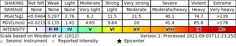
ShakeMap-EU is a collaborative initiative that provides rapid maps of ground shaking service for earthquakes in the Euro-Mediterranean area by integrating data from EPOS services. The earthquake location and magnitude are sourced from EMSC, while the ground motion data come from ORFEUS and the ground motion models are taken from EFEHR and national configurations. ShakeMapEU generates maps for earthquakes with M ≥ 4.0, provided ground motion recordings are available.
The maps help visualise the distribution and intensity of ground shaking, supporting scientific research, emergency response, and risk assessment. ShakeMap-EU aims to enhance accessibility and interoperability within the EPOS framework.
For more details and to access the latest maps, visit https://shakemapeu.ingv.it/